Les terrains de la partie sud de L'Ile Perrot
The Land Concessions on the south shore of Ile Perrot
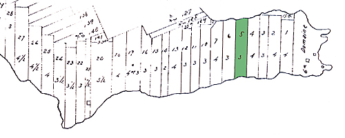
 Cette partie de la carte de l'Île Perrot indique les premières concessions octroyées par Joseph Trottier Desruisseaux ici. Son domaine seigneurial sur l'extréme droite de la carte montre le moulin à vent sur la pointe, la maison du meunier au nord le long de la côte, et le manoir à l'intérieur. Charles avait le lot 5 situé tout près. Il mesurait 3 arpents de large. Il avait aussi un autre lot plus à l'ouest situé à l'Anse aux sable.
Shown above is part of an 1821 map of Ile Perrot indicating the first land concessions granted on Ile Perrot by Joseph Trottier des Ruisseaux. His seigneurial domain on the far right of the map shows the windmill on the point, the miller's house to the north along the shore and the seigneurial manor in the interior. Charles had lot #5 located nearby. It was 3 arpents wide. He also had another lot further west at L'Anse aux Sable.